
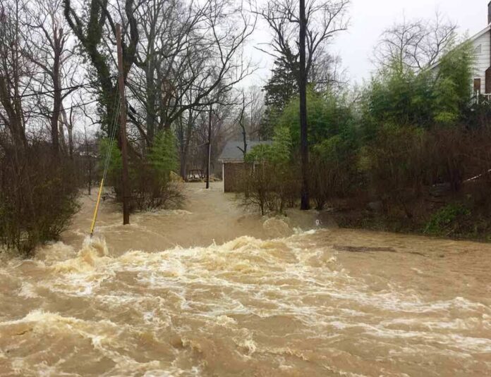
A fast-moving tropical storm drenched Texas-Louisiana border communities with flooding rain, downed trees, and widespread power outages.
Story Highlights
- National Hurricane Center warned of 3 to 7 inches of rain, with up to 12 inches in spots, and flash flooding.
- Storm pushed inland over Southeast Texas, disrupting power and communications while tracking northwest.
- Beaumont and Jefferson County saw flooded roads and tens of thousands lose electricity.
- Forecasters noted a brief tornado risk for southeast Texas and southwest Louisiana.
Heavy Rainfall and Flash Flooding Threat Across East Texas
National Hurricane Center advisories forecast 3 to 7 inches of rain with local amounts up to 12 inches from the Upper Texas Coast into east-central Texas. The center warned that this rain was likely to cause flash flooding, with significant flash flooding possible and river flooding also a concern. Forecasters said heavy rain would continue as the system moved inland through Thursday morning. This rain-first profile matches how Gulf storms often cause the most harm to roads, neighborhoods, and local power systems.
National Weather Service forecasters in Houston and Galveston reported the system moved inland along the northwestern Gulf Coast and would track northwest across East and Southeast Texas. The local statement cited scattered power and communications outages as the storm pushed across the region. This inland track focused flooding and outage risks near the Texas-Louisiana border communities, where the ground and drainage can be quickly overwhelmed by slow-moving rain bands.
Border Communities Hit: Outages and Flooded Roads
Local reporting placed the storm center over Beaumont in Jefferson County, where heavy rain and strong winds toppled trees and flooded streets. About 42,000 utility customers in Jefferson County lost power as the core passed through the area, according to contemporaneous reports. Regional outage counts across Texas climbed above 81,000 by nightfall, as soaking rain and gusty winds stressed feeders and knocked lines down across southeast Texas neighborhoods. Crews began restoration as conditions improved.
Multiple broadcast accounts described landfall near the Texas-Louisiana border with sustained winds near 60 miles per hour and gusts above 70 miles per hour. Reporters and camera crews showed flooded roadways, wind-blown debris, and standing water across low spots around Port Arthur and nearby towns. These on-the-ground scenes aligned with the National Hurricane Center warnings for life-threatening flash flooding in poor drainage areas and along small streams. Drivers were urged to avoid flooded roads.
Wind, Tornado Risk, and Ongoing Hazards
National Hurricane Center advisories flagged a brief tornado risk across southwest Louisiana and southeast Texas as rain bands moved ashore. Even a quick spin-up tornado can down trees and damage outbuildings when the ground is already saturated. Forecasters cautioned that heavy rain and flash flooding would persist inland into Thursday morning as the system weakened, keeping rivers, bayous, and urban drainage under pressure. Residents in low-lying areas were told to stay alert and follow local guidance on travel and drainage safety.
⛈️The storm looked very different depending on where you were in Texas.
Tropical Depression Edouard came ashore near Johnson Bayou, Louisiana, about 15 miles south-southeast of Port Arthur yesterday afternoon. Wind gusts up to 90-mph were recorded in Port Arthur, while Port… pic.twitter.com/l8EyiEpV8Z
— Chron (@chron) September 2, 2026
Some outlets referred to the system as a tropical depression later in the day, while National Hurricane Center products identified it as a tropical storm during parts of the event window. That label shift does not change the key facts: the storm delivered flooding rain, gusty winds, and power outages along the Texas-Louisiana line. For families and small businesses, the practical risk came from water on roads, rising creeks, and downed lines, not only the exact wind classification on a map.
What Texans Should Watch Next
Emergency managers will watch for lingering high water on secondary roads and near bayous as the rain bands move west and northwest. Utility crews will rotate from hazard assessment to repairs as access improves and water recedes. Homeowners should document damage with photos, keep clear of downed wires, and use generators outdoors to avoid carbon monoxide. Officials warn that more rain on already soaked ground can trigger new flash flooding, even after the worst wind has passed.
Sources:
washingtontimes.com, accuweather.com, nhc.noaa.gov